- Home
- Your Lot ¦ Plot ¦ Site
- Site Analysis
- Natural Disaster
Site Analysis & Natural Disaster
Site analysis and natural disaster are probably not what you want to think about towards the beginning of your home project.
And yet an important part of site analysis is to establish whether or not you need to consider the possibility of natural disasters for your home design.
Whether it's flood, earthquake, wildfire or extreme weather, let's take a look at how to find out whether or not your site is at risk.
This page concentrates on identifying risks for US based homes but other countries will have similar information available if you look around.
Flood
The Federal Emergency Management Agency (FEMA) has placed more than 20,000 communities in the United States into a category of flood zones.
To indicate the risks in different parts of the country, FEMA has assigned a character from the alphabet to each zone.
The most hazardous flood zones are V (usually first-row, beach-front properties) and A (usually, but not always, properties near water).
Flood risk will have an impact on your insurance (there’s a national flood insurance program) and on how you build such as your foundations and the materials you use to build your home.
How to find out if your site is at risk of flooding
- Use the FEMA flood map service
- Find out what your flood zone letter is (see legend at the bottom of the flood map) and take a note of it.
- Take a snapshot of the picture and add to the information you're collecting about your site.
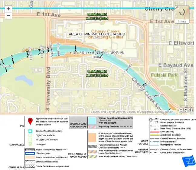 The turquoise blue and orange areas are prone to flooding. The area where our case study is located is zone X - An area of minimal floor hazard.
Earthquake
Take a look at the map below from USGS and find out what the earthquake risk is at your site and the kind of damage you might be in for.
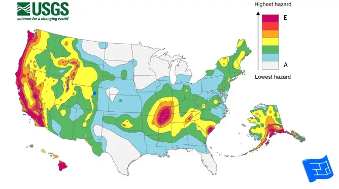 USGS 2018 Long term Seismic Hazard Map
Zones A-E (A-white, E- Red) – there are 3 D levels
- A – no risk
- B – falling plaster
- C - Strong shaking—Damage negligible in buildings of good design and construction; slight to moderate in well-built ordinary structures; considerable damage in poorly built structures.
- D - Very strong shaking—Damage slight in specially designed structures; considerable damage in ordinary substantial buildings with partial collapse. Damage great in poorly built structures.
- E - Strongest shaking—Damage considerable in specially designed structures; frame structures thrown out of plumb. Damage great in substantial buildings, with partial collapse. Buildings shifted off foundations. Shaking intense enough to completely destroy buildings.
What does that all mean? It means that with good design and construction, your home (and you if you're in it) should stay intact in all zones apart from zone E.
- Work with your design professionals and contractor to develop a design suited to your earthquake zone.
- Learn about what the home insurance implications are. There are no federal programs.
Wildfire
In the USA, 13% of homes are at high or very high risk of fire. One third of homes are at a moderate or higher risk.
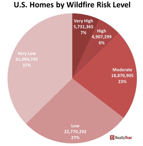
Is your site at risk of fire?
Take a look at this fire danger forecast.
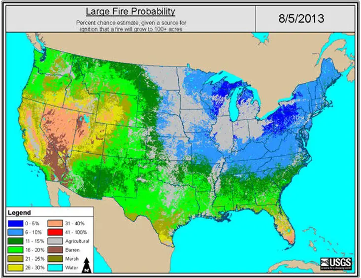
If you want to look more closely, use the USGS Firedanger Viewer.
- Choose if you want the fire potential index (measure of how dry vegetation is) or the large fire probability – I prefer large fire probability – double click on the data set you want in the left hand side
- Put your address in (or a landmark close) to get a pin
- Zoom in on the pin
- You can change transparency of layers in the left hand side to be able to see the streets underneath
Take a screenshot and keep it with your site analysis information.
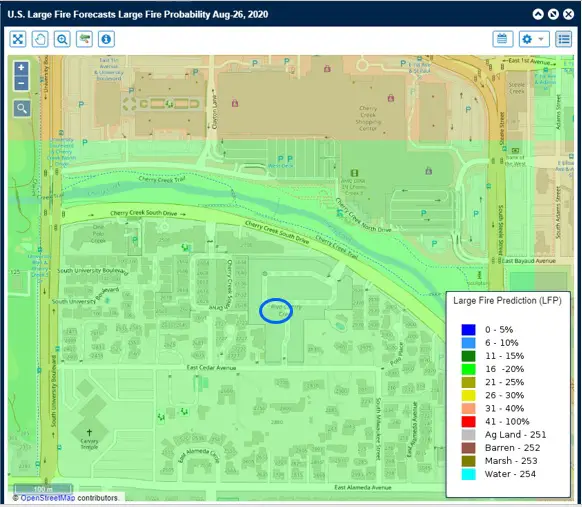 Fire probability for the Denver case study site
Extreme Weather
Is your home likely to be exposed to stormy weather?
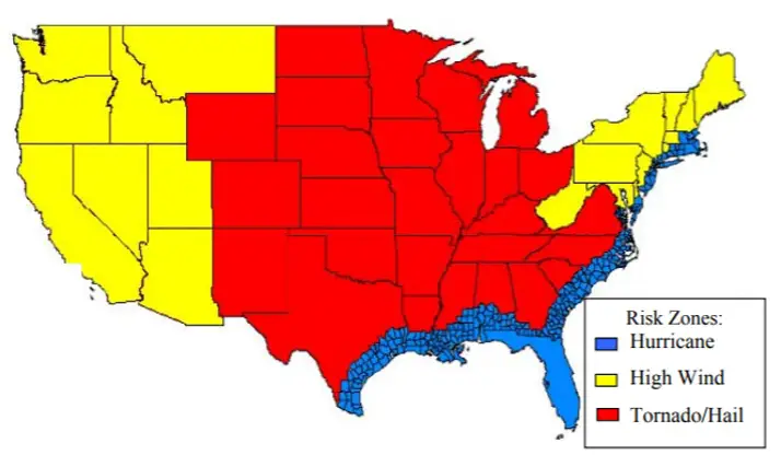
It's also worth using the link below in wrapping up to take a look at the risk of heat wave.
Wrapping Up
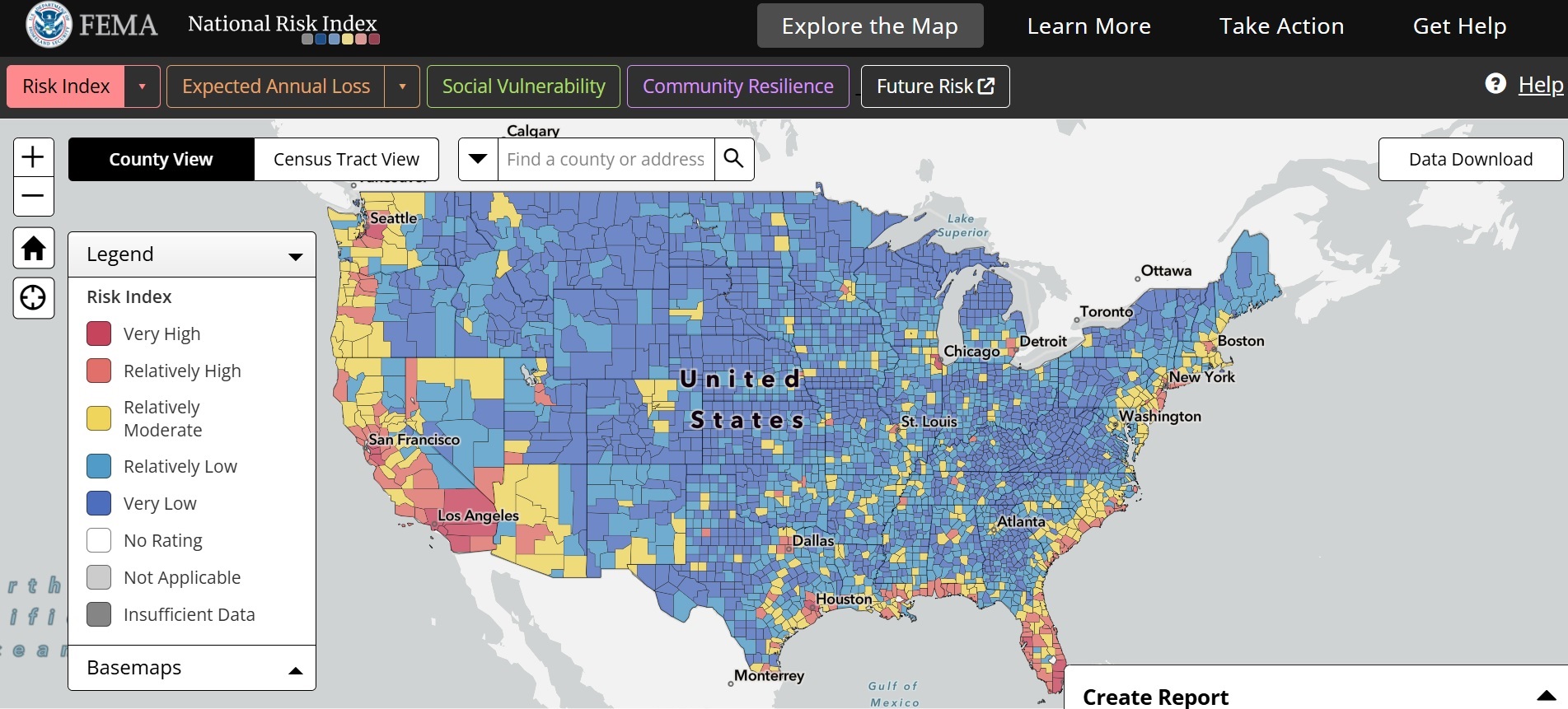
Another good source of information for natural hazard risk profiles is the FEMA National Risk Index Map.
It covers other risks such as ice storm, landslide and avalanche which are also worth considering in your home design.
Just be sure to take some time to understand the methodology behind the results presented. The National Risk Index is not simply a probability of an event happening.
